Showing posts with label Cruising Blogs. Show all posts

Sunday, 18 December 2011

ActiveCaptain route sharing: dangerous, useful, or perfection

ActiveCaptain route sharing: dangerous, useful, or perfection?

ActiveCaptain_route_share_cPanbo.jpg
When I first heard about ActiveCaptain's plan to enable route sharing amongst it users, it was via a group email from a very experienced bluewater cruiser "in absolute shock that a boat owner/skipper navigating a boat through unfamiliar waters would use somebody else's waypoints." I posted the
whole note for discussion in the Forum, but only AC developer Jeff Siegel and I participated. Well, now
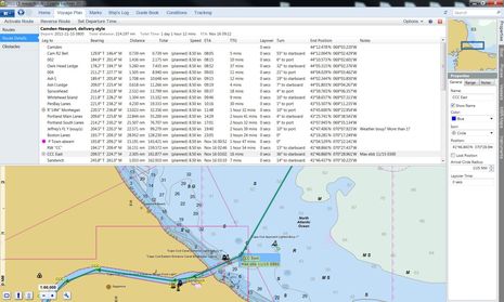
route sharing is fully enabled at the ActiveCaptain site, as illustrated in the screen shot collage above, and I still don't understand why anyone would object, particularly given AC's careful implementation...
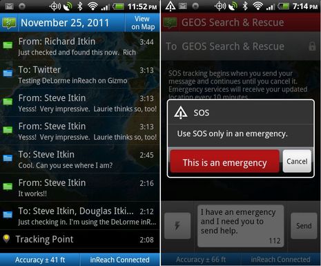
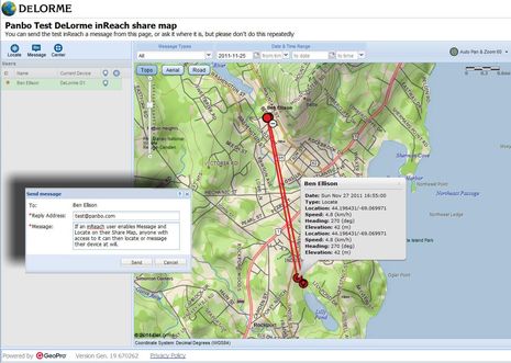
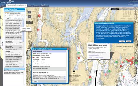
What you can see in the top image is how I searched a particular area of midcoast Maine for available routes by chart view and "start/end" -- there are several other search methods -- and then chose to display one called "Bath to Boothbay Harbor Inside."  I also chose to see the Details box, and I zoomed in to check the work of the creator. In fact, I made this tricky passage many times in my youth -- even in a 35-foot schooner
without auxiliary power, as I once bragged about in an entry citing the strong currents thereabouts -- and I could see that Ron de Moraes had paid close attention to the nav aids and the dangers. Then I right clicked on the route so I could copy it to my own folder (My Card), and that's when I got that blue-background Conditions warning. I thoroughly agree; one does not copy routes without taking responsibility for the consequences.
  I also experimented with importing one of my own routes into AC for sharing, and that's when I discovered a fairly significant limitation. I like to name waypoints in a useful way, especially when using a PC charting program where that's relatively easy work. AC, however strips those names out. There may be a technical explanation for this limitation, but I did notice recently that EarthNC's new routing feature exported .gpx files to Coastal Explorer and Memory Map with custom waypoint names intact....
ActiveCaptain_routing_feature.jpg
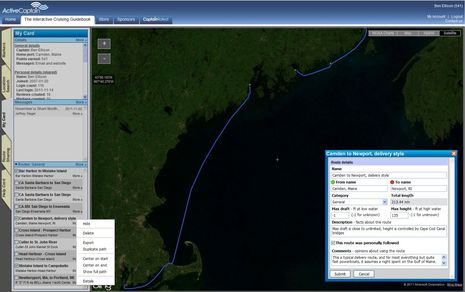
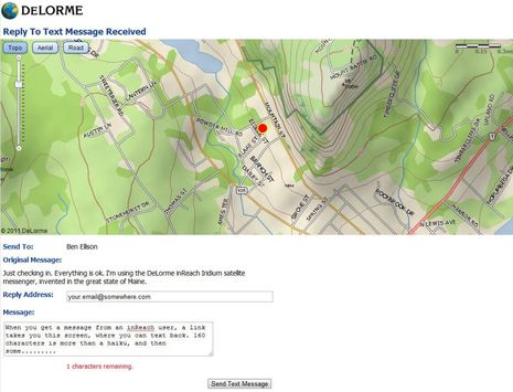
On the screen above is my "Camden to Newport, delivery style" route that you can check out on AC (along with a couple of others that I've copied into my own folder and exported for further checking and possible use in the various programs and MFDs I test). But below you'll see the route's waypoint details that I created in CE which did not get to AC. You can download that Cam-Newport.gpx file here. It would also be nice to pass waypoint notes around -- so, for instance, you could warn a fellow Captain about where the serious current whirlpools can pop up along that Bath-to-Boothbay trip -- but I'm not even sure the GPX format includes notes.
   At any rate, I think that ActiveCaptain's route sharing feature is pretty slick, and that it makes you treat the act of copying a route seriously, but I would like to see sharing of even more details if possible. Have any of you tried it, and what do you think?
Coastal_Explorer_2011_routing_details_cPanbo.jpg

DeLorme inReach, hand's on #1

DeLorme inReach, hand's on #1

SatMessengers_inReach_CerberLink_Connect_cPanbo.jpg
Click on this photo for a close look at the new age of satellite messaging, tracking, and distress handhelds, or at least three of the early contenders. I was cautiously keen on the DeLorme inReach when it first surfaced, but then I had to bite my tongue. Though I was experiencing its reasonably fast and affordable two-way global messaging back in August, I couldn't discuss it because of the beta testing NDA. Fair enough, as the inReach system evolved substantially during the beta process.Plus

I've now had a chance to compare it with the less expensive Spot Connect, whose one-way custom messaging via Globalstar was discussed here in January. Not to mention the pro-oriented BriarTek Cerberus system, which also appeared here last January and which uses the same Iridium 9602 data modem as the inReach. The news is pretty much all good for anyone who boats (or hikes, or whatever) beyond cell service, but it's going to take several entries just to lay out what I've learned so far...

This entry is going to focus on inReach, but let's start with what's common to all three systems. At the center of each is a handheld device containing GPS, a Bluetooth radio, and a one- or two-way satellite data modem. The handheld alone can at least send your position and ID to a private SAR center -- the GEOS bunker in Texas in all cases, I think. The two Iridium handhelds can also send tracking info and canned messages, quite like the regular SPOT. Owners of all three devices get a web portal where their messages and tracks are archived and where they can manage things like service subsciptions, canned messages and share pages (where friends and family can view a subset of what's on the portal). And finally there are smart phone apps that use the Bluetooth connection for at least custom messaging and sometimes much more.
   The DeLorme app -- called Earthmate, and so far only available for Android -- is definitely in the "much more" category. In fact, I've long thought of DeLorme as the mapping and handheld GPS developer most willing to put every possible control and feature into their products, sort of like Furuno is in the world of dedicated marine electronics. That's not necessarily a mistaken stradegy, but it can lead to confusion among some users. I'd say that while Earthmate walks the line between power and ease of use pretty well, techy types will take to it quicker...
inReach_EarthMate_splash_n_map_screens_cPanbo.jpg
So let's take a look behind Earthmate's simple-looking main page. For one thing, this is the only satellite messenger app that includes mapping, and it's serious mapping. You can download a 150 Mb world base map plus North American regions of DeLorme's own high-detail topo-based cartography, at no extra charge beyond inReach hardware and service costs. There's no charting yet, but note that DeLorme is a Navionics partner. And that you can view the maps north- or head-up, specify details like how the scale bar works, and your messages and track points are mapped along with your current position. Which could come in handy if you got lost in the wilderness, even if you were able to call out the SAR cavalry. Note that that the blue icon in Camden Harbor is where I posted a message to Twitter from Gizmo over the weekend. (Yes, the boat is still afloat, which is good as a Simrad 4G radar arrived at the door yesterday!)...
inReach_EarthMate_message_screens_cPanbo.jpg
The screen at left above is what you get when you hit the Messages button and I think it needs some work as it doesn't differentiate between incoming and outgoing texts (which is especially problematic for someone who emails himself ;-). However, when you drill down into a message thread, it's more obvious what's going on. And while I was just goofing with in-laws over the holiday, I don't think I can overstate how revolutionary it feels to be doing nearly real time two-way texting on a Iridium device that by definition can work nearly anywhere on the planet and is not very expensive. Of course the inReach likes an open sky view, but I have successfully messaged and tracked from my office window (looking into a backyard full of trees and high topography) and also from the back seat of a van speeding north from the Portland airport. Incidentally, that "lightning" icon next to the "Type message" box lower right can pull up canned text snippets that you've entered on your DeLorme web portal and then synced with the phone when it was online. See what I mean about every possible feature?...
inReach_EarthMate_tracking_screens_cPanbo.jpg
Above left is Earthmate's main tracking menu. You can set the interval from 10 minutes to 4 hours, and the app is smart enough to lengthen the interval when the inReach is stationary. One thing I don't understand yet is why the phone's GPS is used instead of the inReach's, but I do know that if you close down Earthmate, the tracking is swapped over to the inReach seamlessly. And if you start tracking on the inReach while it's connected to Earthmate, the app hears about it. Note too how inReach and Earthmate send speed, altitude, and heading info along with position, though how the latter is determined when the devices are stationary remains another mystery to me. Also note the red exclamation sign on the left screen. Tapping on that brought up a dialog box explaining that the inReach had not been able to send off the track point -- not surprising given its location -- and giving me the choice of cancelling or trying again. That's a sign of how much communication is happening between phone and inReach and also of an app that's programmed to deal with difficulties.
   Below left is the screen two levels below the History button on Earthmate's main menu. Here we have a day of activitiy with the incoming/outgoing icons the Message screen should have as well as track points, all of which can be queried and shown even with the map of where they took place (if you did the downloading). And, finally, there's the initial SOS screen. Of course in some circumstances you might fire off SOS on the waterproof inReach itself, and I trust that would be effective largely due to the SEND standard discussed in June. But if, say, you got dismasted or blew your engine offshore and could still use the apps phone link, inReach would give you the ability to converse with GEOS and then the SAR agency they passed you to. That's HUGH.
   But does inReach perform flawlessly? I'm not sure. I do know I've had a few Bluetooth connect issues even since I got a production unit (and I admire any company willing to tech support Android Bluetooth issues). And I've also had a couple of instances where the inReach froze up and could only be shut down by removing the Lithium AA batteries. I'm talking to customer support and also watching DeLorme's very active forums. But I've also witnessed how far the company has come with hard- and software in a few months and trust they will keep tweaking toward perfection. Then again I've also seen how differently -- sometimes positively, sometime not -- BriarTek designed Cerberus around the same Iridium module. Overall I still think that this is a terrific new communications technology. Tomorrow we'll look at the Internet side of inReach -- full featured to be sure -- and I'm hoping some of you will help with further testing.
inReach_EarthMate_history_n_SOS_screens_cPanbo.jpg

DeLorme inReach hand's-on #2, text me

DeLorme inReach hand's-on #2, text me!

1
DeLorme_inReach_web_portal_cPanbo.jpg
Following up on inReach hands-on #1 -- which attempted to be both an overview and a close look at its associated Android app Earthmate -- let's check out the Internet side of the system. The screen above is the user's web portal at explore.delorme.com, which DeLorme developed in partnership with GeoPro. Given that GeoPro builds its own pro-level Iridium handhelds, like its new $1,200 SHOUT
Nano, it's no surprise that the portal let's you thoroughly view and manage inReach communications. It could even be used by, say, a fleet manager to keep an eye on multiple inReach units...


In fact, though GeoPro's own web application is not exactly the same as DeLorme's, you'll find more relevant detail at that link than on the current inReach sales pages. The inReach manual, download here, is pretty good but doesn't cover the web portal either. Don't be intimidated by what you see at GeoPro; the portal's many functions become clear once you start using the system, and the typical owner of a single inReach won't have to mess around with many if he or she doesn't want to. The minimum might be entering your emergency contacts and defining the three canned messages and associated contact list that the handheld can fire off by itself. Besides, DeLorme will no doubt improve the interface once feedback from thousands of users starts pouring in. (inReach is picking up electronics awards at a remarkable pace.)
   Perhaps more important, when you send a message to someone via inReach, their first interface with the system is simple and easy, as illustrated below. They get a peek at where you are on DeLorme cartography and a chance to text you back. Messages are confined to the Iridium 9602's short burst limit of 160 characters, but I've found that you can convey a fair amount of information within that limitation. Incidentally, if the recipient tries to reply to your message as though it were a normal email, they get back an email explaining (again) how they have to go to the DeLorme site below to reply. Nice!
DeLorme inReach reply to message page cPanbo.jpg
Plus you can use your portal to set up a share page that gives friends, family, and associates a lot more access to you and your inReach. As illustrated below, I've set up mine so that my people can not only locate me whenever they want, but can also initiate a text conversation. In either case, the Iridium system will then make three attempts to contact my inReach, twenty minutes apart. If it's on, its location will be automatically returned. If the Earthmate app on my phone is also connected, I'll get notified of an incoming message. Unfortunately the LEDs on the inReach will not let me know that it's holding texts, and the system stops trying to deliver them after an hour of not seeing the communicator, but those issues are fairly easily overcome if you simply send off a track point or message from Earthmate.
   At any rate, I think this is a really important aspect of the inReach and other Iridium 9602 systems. As much as boaters want to be able to reach out to folks ashore from time to time, those folks often want their beloved boater in reach even more. So let's test it. I'm not going offshore today, but I will be working on Gizmo the rest of the day (an oil change and installing a Simrad 4G radar top the list). Visit the Panbo inReach share page and give it a try.
DeLorme_inReach_share_map_cPanbo.jpg

Hello Nobeltec TimeZero Odyssey, goodbye VNS

Hello Nobeltec TimeZero Odyssey, goodbye VNS?

Nobeltec_TimeZero_planning_screen_Camden_cPanbo.jpg
The great news is that Nobeltec rolled out TimeZero Odyssey last week, and the introductory price for existing Nobeltec VNS and Admiral software owners is a compelling $199, as seen at retailers like P2 Marine. Odyssey seems to be the same core charting program that I've been enjoying all
season as TimeZero Trident, except that it can't integrate with radars, sounders, or video cameras (thermal or otherwise), and it doesn't support dual monitors, fuel management, or Nobeltec's Ocean Data Service (for serious fishermen)...

Now, I became a fan of Furuno radar integrated with the TimeZero PC charting engine even before I
upgraded to Gizmo's Chart Table 21 rig. But the software involved -- whether you go with MaxSea TZ Explorer or TZ Trident -- rings in at well over $1,000 and you also need a Furuno NavNet3D MFD on board and running. Meanwhile, a major benefit of TimeZero is its gorgeous chart presentation, especially with MapMedia's high res and "fused" photo maps, all of which are free for U.S. waters. For instance, notice how nicely the screen above shows the moored boats in Camden Harbor, or check out the Odyssey video on YouTube.
  One other caveat of TZ Odyssey is that it only runs on Windows 7, which I guess is an attempt to minimize customer support hours, but not a huge deal when these days you can buy a zippy Win7 PC for small money (like the 17-inch LED HP laptop I recently picked up). It also takes a fairly powerful PC to fully appreciate TimeZero, and it's getting pretty obvious that Nobeltec wants to impress and switch over its large customer base of VNS and Admiral users.
   In fact, though I don't see a word about it on the Nobeltec site, the recent P2 Marine newsletter states that: "In other news today Nobeltec announced that during the spring of 2012 VNS/Admiral 9 and Passport Charts will no longer be available. Nobeltec will continue to sell and support VNS/Admiral 11 through 2014." I suppose some die hard users of older Nobeltec products may howl, but I think they've been treated pretty well since Nobeltec became part of the MaxSea/Furuno empire. I've also been running Admiral 11 this season and can attest that it's a solid program with good AIS and NMEA 2000 support, and excellent presentation of Jeppesen C-Map Max Pro cartography...
Nobeltec_Admiral_11_cPanbo.jpg
But even if I was running VNS or Admiral 11 -- let alone an older and, hence by definition, clunkier version of Nobeltec's original charting software -- I'd sure give TZ Oddyssey at $199 serious consideration.
Nobeltec_TimeZero_Trident_Odyssey_cPanbo.jpg

Vetus Hits a Home Run

Vetus Hits a Home Run!

As promised I'm finally back from my travels to METS in Amsterdam and a trip immediately after that to work with all of my friends up in Halifax, Nova Scotia. One of the items that caught my eye at METS was a new bow thruster design that is truly new, and super innovative. The "Rimdrive" as they are calling it is unique and was nominated for a DAME award at the METS this year. Check it out here:
RimDrive Motor
Vetus explains this revolutionary design this way:
"The Rimdrive is an exciting and innovative development in bow thruster design. In contrast with conventional thrusters, the electric motor does not take up valuable space inside the boat. The
propeller forms the rotating part of the electric motor (rotor) and the fixed winding (stator) is mounted in the tunnel. This results in a very compact and self contained thruster."

• Virtually cavitation free and thus very silent
• Proportional control as standard
• Unlimited working time
• Propeller can easily be exchanged
To give you a better feel for how much storage space this baby can create for you under your v-berth, check this drawing out:
So I really can't wait to see one of these units installed in a boat. This was for me the coolest new idea I saw at METS this year.

Friday, 16 December 2011

Simrad Broadband Radar 4G, hand's-on #1

Simrad Broadband Radar 4G, hand's-on #1

Simrad_NSE12_w_4G_radar_Camden_Harbor_cPanbo.jpg
I've looked forward to testing Simrad's new 4G Broadband Radar since I saw it demoed in Fort Lauderdale. And how timely that I got out with it and the rest of Gizmo's test radars over the weekend. Tonight I'm reprising my Seven Sea's University radar webinar, and now I've got fresh material!  (No hard sell meant, but Panbo readers can get the SSCA discount by using the code
"Gizmo" and note that you can watch the webinar any time in the next few weeks if you can't make it tonight). Plus it's been weirdly warm here for early December, so I had a pleasant cruise even if almost all those finely targeted Camden Inner Harbor floats are empty in anticipation of what is surely coming...


Whereas a lot of readers are anxious for a 4G report, I'll start with a summary (but please bear in mind that testing and comparing radars is tricky business). In my view, 4G truly is a significant upgrade from the original BR24 and its 3G successor. It does have more power, better range, and better horizontal resolution. Higher possible automated rotation speed will no doubt improve close-in tracking of fast targets (I only got one lobster boat to test that theory on), and the new dual range feature -- if you have an MFD that supports it -- is the absolute bomb. But can it faithfully produce the range of a 4kw radome or the beam width of a 3.5-foot open array? Is it true that "Broadband 4G Radar signals the death of pulse" radar? Sorry, but that kind of talk is premature, I think.
   Not that 4G didn't impress me mightily. Click on that top screen for the highest detail of Camden Inner Harbor, both in range resolution and horizontal resolution, that I've ever seen from a radar antenna 24-inch or less. And note that the radar overlaid over the chart window is operating at a greater range with completely independent controls, something I've never seen before even though the Furuno DRS2D, last discussed here in June, and the Raymarine RD418HD can both do dual range...
Simrad_NSE12_w_4G_radar_12m_cPanbo.jpg
Above is a look at 4G set to 12 mile range with Gizmo off Camden and headed South toward Owl's Head. You can also see the controls available to get the most out of the "B" side of the 4G (it really is like having two 4G radars at work). I have Target boost on "high", Target expansion enabled, and the threshold for weak signals turned down fairly low, all of which should help with distant targets, I think. And there are more distant targets than shown, even if they are radar-absorbing evergreen foliage on sloping terrain. The other radars, even the 2kW Furuno, showed more of the distant topography, which I'll illustrate in a coming entry.
   Now out in open waters, I might use the 12 mile range or greater to check navigation against good targets like headlands and lighthouses, or to monitor vessels that might not have AIS, and 4G might do alright with the gain cranked up...
Simrad_NSE12_w_4G_radar_dual_overlay_cPanbo.jpg
But the screen above better illustrates how I'll likely use 4G for coastal cruising, and if you appreciate overlay and maybe even 3D, it's extraordinary. Radar overlay imagery is always a bit "dumbed down" to make it show decently on a chart, but those are two completely independent overlays, and all the tweaks seen in the menu further above can be applied to each. What's also telling on that screen is that some targets are showing up behind Gizmo, despite the fact that the 4G is mounted on the front of the flying bridge with quite a lot of obstructions behind it. Super low power Broadband is sensitive to onboard obstructions, but the BR24 that used to run from the same spot never saw targets much abaft the beam. Definite power improvement.  (Yes, I ought to put the 4G up on the mast to more fairly compare long range performance, but it's crowded up there, the lower mount does help with extreme near range performance, and I'd be a dite nervous to point a magnetron beam so directly at, and close to, my body.)....
Simrad_NSE12_w_4G_radar_cPanbo.jpg
Above is another useful cruising mode, with independent close range overlay on the left and 6 mile straight radar windowed on the right. Note how the offset long range is actually seeing hills and islands at about 8 miles. I believe that's better than previous Broadbands, somewhat comparable to the good HD radomes, and that you would make out larger vessels at that range, especially in more open waters. But note also how 4G's "beam sharpening" is separating the ledge and buoy pair about a mile ahead. That's very hard to do with the 5 degree beam width typical of an 18-inch radome.
   Now an important caveat. Note how the screen below, taken nearly at the same time as the one above, does not seem to have the beam sharpening in action (and does not identify A and B radars). That's because it was taken on the Simrad NSS8 which is also onboard Gizmo these days. It's a fine MFD, and better than when I first tried NSS in Spain, but it does not support the 4G dual range feature. It does show beam sharpening, which is a bit confusing on Simrad's BR comparison table, but I'd have to reduce the range on the right window for the horizontal detail to show up on the left window. (This caveat also applies to the Lowrance version of 4G.) Would a Simrad NSE with its apparently more powerful processor (and its wonderful quick mode buttons) be nice with touchscreen added? Heck, yes!
Simrad_NSS8_w_4G_radar_cPanbo.jpg

Lowrance HDS Gen2, with StructureMap!

Lowrance HDS Gen2, with StructureMap!

Lowrance_HDS_Gen2_StructureMap_video.jpg
The breaking news today is that Lowrance is out with the new HDS Gen2 multifunction display series, and it has enough processing power to support an interesting new feature called StructureMap. Of course you need to have a StructureScan module and transducer networked to the MFD(s), but then you can see its output overlaid onto your chart in real time and/or save the scans for later
perusal. The video on that HDS Gen2 page is the best way to get a sense of StructureMap, I think...


Of course the best way to see how well StructureMap works will be on the water, which I anticipate with relish. As well as what I hope is the inevitable adoption of the feature on Simrad MFDs. As a long time fan of StructureScan, and Humminbird's original Side Imaging, I welcome new ways to interpret the data. I even wrote an entry describing how to use unmapped SS, and though I use it all the time to poke around the coast of Maine, it'll be great if there's an easier way to relate the imagery to a chart. However, this sort of semi-transparent overlay with some chart items on top, some underneath, is tricky stuff, and I'm reserving judgement...
Lowrance_HDS_Gen2_StructureMap.jpg
At any rate, there are no less than seven models in the HDS Gen2 lineup, and now they all seem to have the LED screen backlighting technology that still looks good on the original HDS10. What I don't see is any mention of are the advanced Broadband 4G radar features discussed here yesterday. But maybe the increased processing power makes dual independent radar ranges and/or Beam Sharpening control a future possibility? Lowrance has been good about regularly adding improvements to the existing HDS series, like the shortcut keys to favorite pages added last summer. However, that may mean Lowrance HDS Gen2 sports no other significant new attributes, besides StructureMap and increased speed (always a good thing). Or am I missing something?
Lowrance_HDS_Gen2_family.jpg

Vesper Marine AIS-DSC calling, merry Christmas (again)

Vesper Marine AIS-DSC calling, merry Christmas (again)

Vesper_aisWatchMate_DSC_calling_cPanbo.jpg
I'll venture a guess that Vesper Marine won't commit to giving Christmas "prezzies" to their AIS WatchMate customers every year, but the company is following up on its terrific 2010 anchor watch software gift with another free update feature that lets users place direct DSC calls to AIS targets if
their WatchMate model 670, 750, or 850 is set up to output NMEA 0183 to a compatible VHF radio. But I fear "compatible" is the key word here, and I caution WatchMate owners not to set their expectations high, though I think that this is a very worthwhile experiment...


What Vesper has added to its latest firmware -- which you can get by filling out this online form -- is some code that makes a WatchMate output a standard NMEA DSC message that will instruct your VHF to set up a direct DSC VHF call to a specific AIS target on the working channel of your choice. The concept is great; a target's VHF should have the same MMSI number as its AIS, and a call like this is hard to miss when it loudly rings. I've tried direct AIS target calling with a Garmin VHF 300 networked to a Garmin MFD, and also with a Standard Horizon GX2100, which has all the needed elements built in. It can work very well, and could be just the wake up call needed on the bridge of a critical target (though I've seen that sometimes even pros aren't familiar with responding to a direct DSC call, which often requires a button push).
   And frankly I didn't even know for sure that there was a standard NMEA command message -- 0183 or 2000 -- to set up DSC calls, and I doubt that many radios know how to use it. Vesper has tested the feature successfully with an Icom M412 and expects it will also work with the M504 and M604 series, but I understand that early versions of these radios need firmware updates to even do direct AIS calls from Icom's own MA-500TR Class B transponder. At any rate, Vesper is approaching this feature as an experiment and hoping that users will help them build a list of radios that work. One thing I can report is that the update is easy to perform, at least on the WatchMate 850 because it can be powered by its USB port. It's also worth noting that the NMEA 0183 connection can supply GPS info to your radio if it's present in the WatchMate.
I can also report on the utility of Vesper's last Christmas present. I used the 850's anchor watch screen quite a lot this season and am quite fond of it. The screen below shows many hours of use while Gizmo was laying to two anchors during Hurricane Irene. I could have used a radar to assure myself that the boat was not dragging during that long, gusty night (the motion documented is just a combination of tide level and wind direction changes) but this tool was easier to use and a lot more power efficient. I have suggested to Vesper that the vessel icon be a simple dot when Heading is not available, but the better solution to this issue is a NMEA 2000 port that will make Heading easier to bring in, as seen in Vesper's 2012 product line up!
Vesper_aisWatchMate_anchor_watch_cPanbo.jpg

Stylin Shore Power.....NOT!

Stylin Shore Power.....NOT!

Every now and then either I or one of my buddies comes up with a real work of electrical art that we need to share in our hopes that readers here will get the idea that we're watching you and if you mess up, sooner or later one of us is going to expose you. This week's little nugget comes from my friend Dexter who was working on a customer's boat here at the boatyard and discovered a real gem of a double pole circuit breaker installation. This goes well beyond the Tupper Wear plastic box installs we sometimes see. Check this out people:
The interesting part about this first class horror show is that the poor person who now owns this boat just bought it. I wonder if they bothered to get a survey before they jumped into this beauty? If they
did, I really want to meet the surveyor so we can have a few words..............

So, for those who are having difficulty understanding what they are looking at, let me provides some details
here. ABYC requires a double pole circuit breaker to be installed on the shore power inlet to a boat so equipped (with shore power that is.) So the mouseketeer that did this got that part sort of right. But they didn't get the part right where we require terminations to be made inside enclosures that require hand tools to get at any live terminals. The piece of twine securing the breaker to what I'm told is the diesel fuel tank vent line is really quite stunning. It looks quite snug and tied with good knots...............
Folks, when I see things like this it just further supports a theory that I've begun to embrace more and more as I get older. The term "common sense" is an oxymoron. People, when it comes to shore power voltage potentials, do it or get it done professionally. This stuff is lethal and is no place to cut corners.

It's Beginning to Look A *Little* Like Christmas...

It's Beginning to Look A *Little* Like Christmas...

by Brittany & Scott on s/v Rasmus
image-img 3890
Add caption
Windtraveler
I think it really is the most wonderful time of the year and my Christmas memories are nothing but warm and fuzzy.  My dad was something of a Clark W. Griswold when it came to Christmas growing up and I just loved the magic he created around our family during this time of year.  I am a
self-proclaimed Christmas junkie.  I love the decorations, the get-togethers, the ugly sweater parties, the music, the reflection, the togetherness, the eggnog, the family traditions, the movies (Oh, the movies!)...I just eat it all up and feel like a little kid inside all over again.


That said, I have to admit:  It just doesn't feel like Christmas down here.  I can't put my finger on why, exactly, but something is missing.  The grocery store is playing Christmas music, there are decorations here and there around town, and some private homes even have lights...  I have been playing my Christmas playlist on a loop for the past week, watching Christmas movies each night, I've decorated the boat, and I've even done a little Christmas shopping, but it still doesn't feel the same.
But - because of this effort on my part - it is starting to feel a little like Christmas, and that makes me happy.   What makes it even better is the fact that I get to go home for the holidays this year!  Scott, unfortunately, will be captaining Diamant on their Christmas cruise, so we would have been apart anyway and the idea of spending Christmas in the harbor alone was a little depressing.  So... as the old song goes: I'll be home for Christmas, you can plan on me!
For once in my life I cannot wait to get home to the cold.
Love,
Brittany & Scott

Open N2K to WiFi, Chetco SeaSmart & DMK Yacht Instruments

Open N2K to WiFi, Chetco SeaSmart & DMK Yacht Instruments

Chetco_SeaSmart_data_on_Panbo_iPad_cPanbo.jpg
It took me less than an hour to cable a sample Chetco SeaSmart E-Net to Gizmo's NMEA 2000 network and WiFi router and use the boat's PC to scan for its IP address, which then yielded screens like the "Weather Info" browser page above on both my iPad and Android Incredible phone. Cool!  And if I was actually proficient at the sort of IT stuff represented in that SeaSmart "Network Setup" screen, it probably would have been quicker. Admittedly there are some issues with that data -- Gizmo was not pitched 30
degrees, for instance! -- and I've got a lot more testing to do, but I am excited about the growing number of devices designed to gateway NMEA 2000 (and other boat sensor data) out to Ethernet and WiFi in forms that can be easily displayed, or, better yet, easily used by any software developer...
I wrote about Chetco Digital's various SeaSmart devices in February, and was pleased to meet
the principals Steve James and Joe Burke in Fort Lauderdale. I've also mentioned how Digital Yacht's BOATraNET is getting N2K compatability, as well as specs published for developers about how the PGN data is encapsulated (like Chetco offers). And of course Maretron was really first up with its IPG100, also covered here last February -- and now it's gone on to solve off-boat monitoring issues like fixed IP addresses with its new Maretron Cloud Service. But Maretron's gateway serves data exclusively to its own PC and mobile software, at least so far, and there are  boaters out there dreaming about what an open apps world with access to multiple boat sensors could be like...
Chetco_Digital_Steve_James_and_Joe_Burke_cPanbo.jpg
Those folks will be excited to hear about a brand new company, DMK Yacht Instruments, which has developed a WiFi gateway purportedly able to broadcast NMEA 0183 and Raymarine SeaTalk sensor messages as well as N2K PGNs. The box is available on Amazon for $399, a free demo iOS app is up on iTunes, and DMK is hoping developers will use its reference materials to put the data into their own apps. I think I'll get to try a DMK box myself, and have a feeling I'm going to learn some added IT skills this winter. In the meantime, I wonder what developers and informed users think of the various N2K-to-WiFi schemes discussed here.
DMK_multi_protocol_boat_sensor_to_iPad_app_screen.jpg

Super light VHF handhelds: Icom M24 vs Standard Horizon HX300

Icom_M24_float_n_flash.jpg
Super light VHF handhelds: Icom M24 vs Standard Horizon HX300

I've been meaning to write about the Icom M24 handheld VHF for some time. While I haven't actually tested this model myself, just holding one at a boat show was a revelation about how light and hand-friendly a full-featured portable marine radio can be these days. Apparently Standard Horizon was also impressed, because today they announced an HX300 model that seems very similar...

I put a disclaimer on the comparison image below because I'm not positive I scaled the photos precisely, but while Icom specs the M24 at 9.2 ounces with a body W/H/D of 2.3" × 5.06" × 1.36", SH is claiming 8.8oz in 2.32" x 5" x 1.34". That's close! And it's remarkably light when you consider that each company's previous light weight floater -- the M34 (which I have tested and like a lot) and the HX290 -- come in at around 11oz. A couple of ounces carried around all day does make a difference. (By way of comparison, an iPhone 4S weighs 4.9oz.)

   Yes, both the M24 and HX300 float, and they also both fire off flashing LEDs if dropped overboard. And both can transmit at 1 or 5 Watts and boast "powerful" 600 mW audio on the receive side. Plus both use cell-phone-style replaceable 3.7v Lithium-ion batteries. Icom rates its capacity at 1590 mAh or 10 hours of "typical operation" -- defined as 5% transmit, 5% receive, and 90% standby -- while Standard Horizon cites its battery as 1,650 mAh capacity, but so far without an estimated run time, which is not necessarily proportional due to variable power efficiency. Both radios have internal charging circuits, though Icom's is driven by an included 120/240v wall wart, or optional 12v cable  while SH has gone with a standard USB charging interface. I don't know which charges faster...  
Icom_M24_vs_SH_HX300_cPanbo.jpg
So these are very similar, and similarly attractive, VHF handhelds. And they seemed priced reasonably, with the M24 now at about $130 on the street, which may come down when the HX300 starts shipping in January with a retail price of only $150 (assuming it receives FCC approval). What I can't really comment on yet is their comparative performance and operating systems. Sure both have similar "Tag" or "Preset" functions that let you specify the channels you like to scan, but SH is touting a new E2O (Easy To Operate) menu system that I'm not familiar with. It would be great to hear from readers who have lived with an M24, while we wait for Standard Horizon to put up an HX300 product page and for people to actually use them.
   Incidentally, I don't mean to knock SH for trying to at least match some good ideas dreamed up by competitor. That's sensible, and generally good for consumers. Besides, Standard has plenty of innovations under its belt, and that definitly includes another radio announced today. That's the GX1700, the first fixed VHF radio with a GPS built in, as already noted by my friend Glenn Law. I'll have much more detail on it soon.
Icom_M24_vs_SH_HX300_closeups2_cPanbo.jpg